


Enterprise GIS
The right enterprise geospatial information system (GIS) is a richly featured mapping and analytics platform that helps you meet your goals. Our team identifies your specific geospatial needs, then helps you select, implement, and maintain a GIS enterprise platform, so you can make the most of your GIS data. Enhance data-driven decision-making and operational efficiency with a GIS platform that fits your business.
Expertise
A GIS enterprise platform scaled for you. Now and in the future.
From assessing your current IT environment and goals to configuring and maintaining your new GIS enterprise platform, we’ve got you covered. Our experts implement the foundational systems, including software, hardware, and databases, that work together to produce geospatial data and visualizations. Enjoy a new system that connects to your existing IT infrastructure and data sources—and is flexible to meet your future needs.
Requirements Analysis
The foundation of a successful GIS enterprise implementation is understanding your unique needs. We collaborate with your stakeholders to analyze and map workflows, data sources, and IT infrastructure across your organization. By identifying pain points, use cases, and business objectives, we help streamline your processes and design a GIS enterprise system tailored to achieve your strategic and operational goals.


Platform Selection
Commercial, custom, or open-source—which GIS software best fits your needs? After defining your requirements and priorities for a new enterprise system, we evaluate platforms such as Esri, QGIS, VertiGIS Studio, Google Earth Pro, and custom solutions to identify the best fit for your objectives. Our team develops a comprehensive requirements matrix, assessing each platform’s performance, compatibility, cost, and support. This process ensures you have a clear understanding of your options, empowering you to make a confident decision that balances functionality, support, and budget.
Architecture Design
Whether on-premises, cloud, or hybrid, we simplify the decision-making process. Collaborating with your IT team, we align standards, security, hosting, licensing, and provisioning requirements to meet your geospatial needs. Starting with conceptual diagrams, we design and build robust, scalable infrastructures tailored for your organization. Designed for future growth and adaptability, these systems provide a strong foundation for your GIS enterprise platform.


System Deployment
See your GIS platform come to life. When it’s time to set up your system, we work with your IT team to deploy secure, high-performing hosting environments. We handle everything from configuring hardware to installing and fine-tuning GIS software. By setting up development, testing, and production tiers, we make sure updates and changes happen smoothly. We also set up geodatabases, add security features like MFA and SSO, manage user access, and organize data. After deployment, we run tests and security checks to ensure everything works well and meets compliance standards.
Integration Services
Your GIS system should integrate smoothly with existing and future IT infrastructure, software, and applications. We connect spatial and non-spatial data across your systems, ensuring seamless communication within a single application or tool. Using SDKs, APIs, and REST services, we integrate third-party data and enable map visualizations. Our team embeds web maps into non-GIS software, creating data flows, streamlining processes, and enhancing accessibility. By breaking down data silos, data is accurately transmitted to both GIS and third-party systems, providing a comprehensive view for better decision-making.


Maintenance and Support
A well-defined and consistently followed maintenance plan is essential for the long-term health of your GIS system. We collaborate with you to establish roles and responsibilities, ensuring planned tasks like database administration, patches, security audits, backups, and server tuning are handled efficiently. Our support also includes responsive assistance for unplanned events such as system overloads or natural disasters. Using tools like our custom ArcGIS Content Backup solutions, we help you maintain a resilient, reliable GIS environment designed for continuous improvement.
Our Clients
Hundreds of clients. Thousands of GIS projects.


The system that Resource Data developed allows us to easily manage map tiles and ensure our web maps are consistently up to date. For Intermountain Gas, this functionality has become an indispensable addition to our enterprise GIS environment.
~ Lance Elroy, GIS Manager, Intermountain Gas
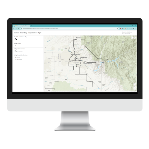
Boise School District
Updating GIS for better zone and bus boundary management
Boise School District (BSD) tracked and managed school attendance zone boundaries, routed buses, and determined student eligibility to ride buses using a local GIS. But with zone boundaries changing frequently and its systems not keeping up, the District became overwhelmed with managing the high volume of complex GIS data and keeping it updated.
Resource Data replaced the old PDF maps BSD was relying on with online, interactive maps for school zones, from elementary to high school. We built an automated process to determine student eligibility for riding buses, wrote custom scripts to automate internal processes, and upgraded the District’s GIS to the latest enterprise software. These modern and reliable systems have helped BSD staff manage and update GIS data efficiently. It’s also easier for parents to check whether their kids are eligible to ride the bus to and from school.
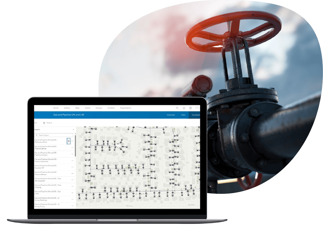
Midstream Oil and Gas Company
Streamlining Pipeline Data Management
A San Antonio-based midstream company needed an authoritative system to manage their extensive pipeline and asset data. Their existing data was stored in a variety of feature classes. Because most of the attributes were open-text fields, it increased the likelihood of errors and inconsistent data entry.
Resource Data customized and deployed Esri’s Utility Pipeline Data Model (UPDM), an industry-standard schema, ensuring that all features and their attributes were standardized and mapped correctly. Our team trained the company’s IT and GIS staff on how to manage their assets and back-sync their production data with development and test environments.
The new data-management system standardized the way employees work with their data, boosting data accuracy and operational efficiency. Their new model’s sophisticated network-tracing tools improve essential analysis, management, and compliance reporting.
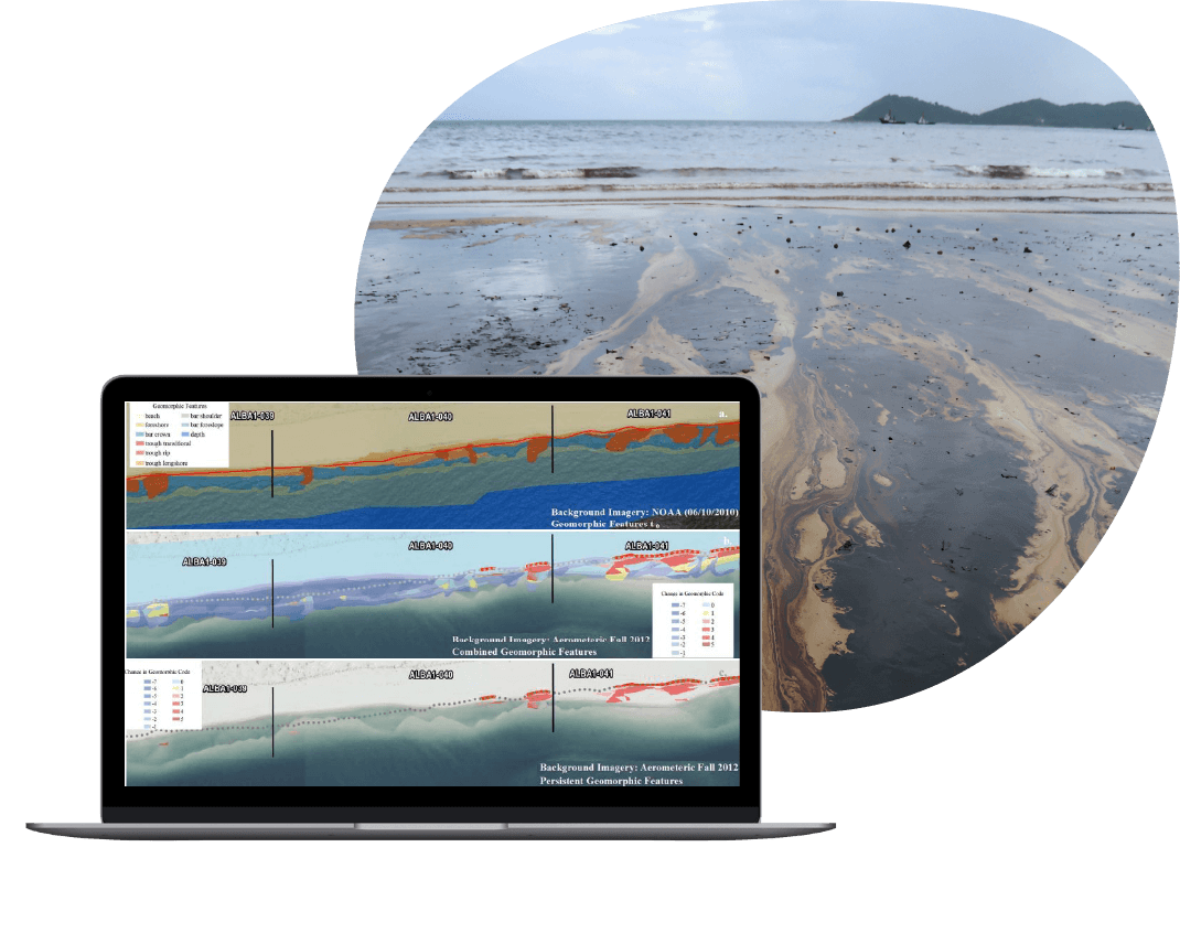
Major Oil and Gas Company
Custom GIS for successful incident response
When a major oil spill occurred in the Gulf of Mexico, the client needed to know where and how the oil was spreading, how it was impacting the environment, and which resources were available to respond. Resource Data led the GIS response team and built custom web and mobile apps that provided spatial information crucial to guiding clean-up efforts and evaluating the effects to the Gulf’s natural resources.
The applications helped coordinate around-the-clock spill response work by BP, the U.S. Coast Guard, NOAA, the EPA, four state agencies, and multiple contractors successfully. The field data became more accurate and was used daily to support the ongoing response and meet federal reporting requirements. More than 50,000 National Resource Advisor reports were filled out and gathered during the response effort. And over 1,000 people used our applications throughout the cleanup.
Enterprise Solutions
Your GIS Platform. Your Way.
When it comes to GIS enterprise platforms, you have options. From analysis to selection, we’re by your side helping make the decision easy. And whatever you choose, we’ll set you up for success, unifying your GIS technologies and workflows across your organization.

Commercial
A commercial enterprise GIS platform is a feature rich mapping and spatial analysis software that requires licensing fees. They typically provide support, updates, patches, and can be quicker to implement. Our certified experts can implement, integrate, configure, support, and enhance your commercial platform. Whether Esri’s ArcGIS Enterprise, Online, Desktop, or other commercial enterprise systems like Mapbox, commercial platforms offer comprehensive foundational GIS systems for mapping, visualization, analytics, and data management.
Open-Source
Open-source GIS software offers free tools and no licensing fees, reducing GIS system implementation costs. Since it’s customizable, our developers can tailor the software to your specific needs and specialized use cases. With its strong community of users and developers, open-source GIS also sees continuous improvements and new feature development. From Quantum GIS (QGIS) suite and GeoDa to Google Earth Pro, Geoserver, and MapServer, we’ll set your GIS software up so you can accomplish your goals.
Custom
Some enterprise GIS platforms might be too costly, have too many bells and whistles, or are missing features essential for your organization. We can customize your existing platform or build a new system that matches your exact workflows and needs while keeping it scalable to quickly and easily meet new requirements. Plus, custom solutions are designed with your technology, your team’s skillset, and your business needs in mind.


Tasha Jackson
Service Area Lead, GIS
Tasha leads the delivery of innovative geospatial solutions for clients across all industries. Known for her technical excellence and strategic vision, Tasha has over 15 years of experience managing complex GIS and IT initiatives across industries, such as oil and gas, utilities, and state and local government. She is an expert at understanding our clients’ business objectives and guiding organizations through the practical use of GIS tools and products to make informed decisions.
Tasha’s expertise spans GIS solution design and architecture, spatial analysis, enterprise system integrations, and data governance. With a strong foundation in geography and natural resource management from Western Washington University, she combines academic rigor with a practical, solutions-oriented approach. Tasha leads with collaboration and innovation, directing project teams to deliver impactful, user-centered geospatial products. Under her leadership, Resource Data continues to set the standard for delivering GIS services which support our client’s strategic business goals.
Our GIS Services
Chart your course with GIS.


Talk to Tasha Jackson

"*" indicates required fields
What happens
next?
- We'll schedule a conversation
- Share your challenges and goals
- Plan your journey together