


GIS Data Management
With GIS data management best practices in place, your large geospatial datasets will no longer hinder your ability to derive timely and accurate insights. Our GIS and data experts help you improve your data handling processes, ensuring your data assets meet the highest standards for quality, reliability, and security.
Expertise
Realize the full power of geospatial intelligence.
Our GIS data management services enhance the quality and usability of your geospatial data throughout its lifecycle. We focus on establishing standards, policies, and best practices for all data-related activities—collection, storage, analysis, dissemination, and more. The result? Accurate, traceable, and accessible spatial data that helps you achieve your business’ objectives.
Data Creation and Cleaning
Start your next GIS project with accurate, comprehensive, and up-to-date geospatial data. We manage vector and raster data by building out data schema and architecture that meet your business requirements. Our team defines data fields and formats for accurate data structuring and sets up data containers. We create data by digitizing source materials like maps and drawings and smooth the process of moving data between systems. If your existing data needs refining, we clean it, so it meets strict quality standards and conforms to your specific business rules.


Data Governance
Strong data governance practices means GIS data is collected, managed, and maintained consistently across an organization. We work with you to define clear responsibilities for maintaining geospatial data and identify authoritative sources of information. Our team outlines terms of use, determining whether data can be shared publicly or restricted to certain users. Through comprehensive metadata, we also provide critical details about data origins, limitations, and governance contacts. Well-governed GIS data is easier to access, share, and integrate across departments. The results are accurate, reliable, quality datasets that support more effective decision-making.
Data Flows and Transmission
Whether through live access or downloadable formats, we facilitate the movement of data across different systems and between users, ensuring it’s always available for the applications and reports that depend on it. By publishing Data as a Service via REST APIs, you get real-time access to your GIS data through web services. This enables smooth and standardized communication and data exchange. We also provide downloadable data files for integration into other systems or applications, giving you the flexibility to work offline or in separate systems for further analysis. With seamless data flows your on-demand GIS data is more versatile and usable in various workflows or systems.


Data Security
How do you keep your geospatial data secure and protect it from unauthorized access and breaches? Our solutions make your data accessible to staff and stakeholders who need it while maintaining strict security controls through configured users, systems, and access levels. Plus, we set up collaborations between different GIS environments for controlled data sharing across organizations.
Quality Assurance
Make sure your GIS analyses and applications are working from the most reliable, current, and accurate geospatial data. We run data quality checks—either manual or automated—based on established business rules to identify and correct issues. We then work through a structured process to fix problems, ensuring data is up to date and conforms to required standards. As business rules evolve, our team continuously refines our quality checks to maintain data integrity, ensuring your data remains accurate and complies with business and regulatory requirements.

Our Clients
Hundreds of clients. Thousands of GIS projects.


We wanted to identify how Alaska Municipal League (AML), as a member services organization, can help meet the identified needs of our members. The data collection and identification of potential projects is important so that AML can better connect members with our technical assistance and support systems. Because of the Alaska Energy Hub that Resource Data developed, the Energy Ambassadors and community leaders now have a really easy path to submitting projects.
~ Nils Andreassen, Executive Director, Alaska Municipal League
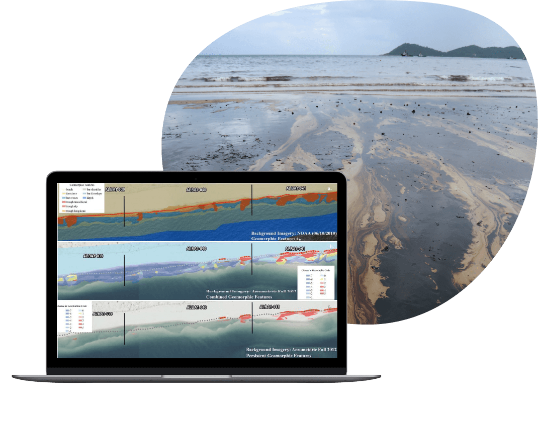
Gulf Coast Restoration Organization
Managing data to help restore the Gulf Coast
When a major oil spill occurred in the Gulf of Mexico, Resource Data built custom applications and led the GIS team that provided crucial spatial information in the spill-response efforts. After the crisis, the Gulf Coast Restoration Organization (GCRO) was established to manage and facilitate the use of this vast collection of data for environmental restoration, litigation, and scientific research.
Since the founding of GCRO, Resource Data GIS experts have provided a wide range of GIS data management and support. We have performed data cleanup, including creating “golden” datasets to reflect extensively validated and normalized information, conducted data analysis, and built custom tools. This has included a GIS and file-inventory tool that allowed analysts to locate files by type (photos, documents, GIS), collect metadata, and consolidate data into consistent and complete datasets.
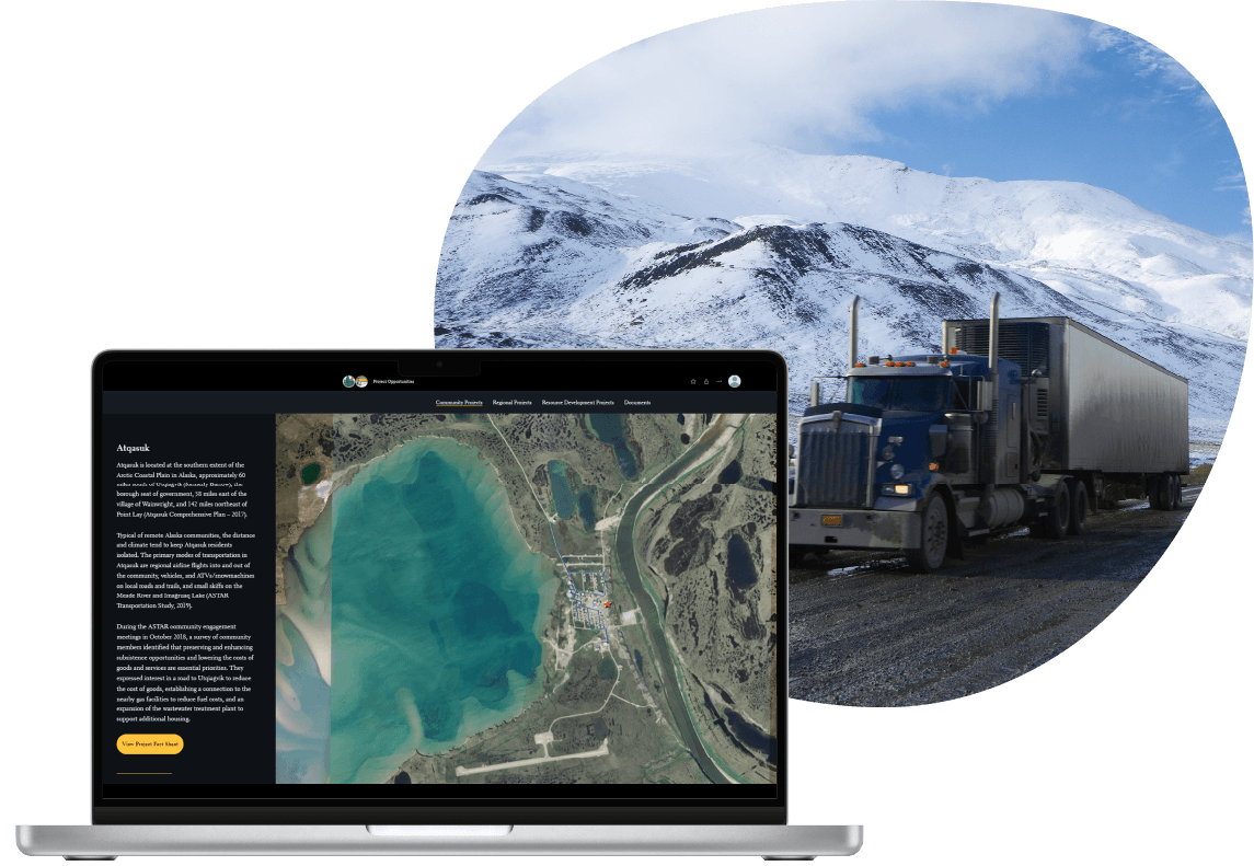
Alaska Department of Natural Resources
Better data management to advance arctic infrastructure projects
The Arctic Strategic Transportation and Resources (ASTAR) program aimed to identify and advance infrastructure projects that would enhance the quality of life and economic opportunities in North Slope communities.
Resource Data developed a comprehensive data-management plan that established standards, protocols, and technical strategies for data storage to support ASTAR work. Our team created an extensive inventory of GIS infrastructure datasets for the Arctic and conducted a thorough gap analysis. We developed a collection of new transportation and infrastructure datasets to address these gaps after working with the Alaska Department of Natural Resources (DNR) and their partners. The datasets became essential for prioritizing and selecting sites for Arctic infrastructure projects.
The DNR used the data-management tools and services we provided to generate detailed project information, outreach materials, and statistical analyses. This made it simple and efficient to evaluate and recommend projects that would benefit North Slope communities.
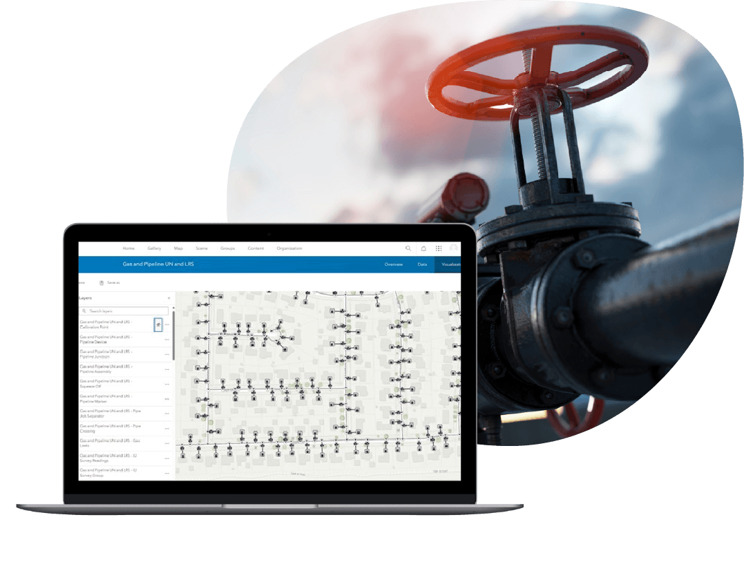
Oil and Gas Company
Streamlining pipeline data management
A San Antonio-based midstream company needed an authoritative system to manage their extensive pipeline and asset data. Their existing data was stored in a variety of feature classes. Because most of the attributes were open-text fields, it increased the likelihood of errors and inconsistent data entry.
Resource Data customized and deployed Esri’s Utility Pipeline Data Model (UPDM), an industry-standard schema, ensuring that all features and their attributes were standardized and mapped correctly. Our team trained the company’s IT and GIS staff on how to manage their assets and back-sync their production data with development and test environments.
The new data-management system standardized the way employees work with their data, boosting data accuracy and operational efficiency. Their new model’s sophisticated network-tracing tools improve essential analysis, management, and compliance reporting.
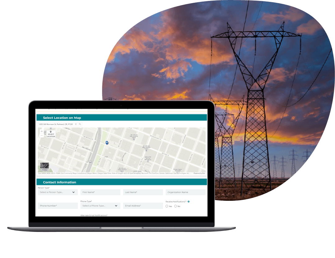
Electric Utility
Integrating systems and updating processes for faster electrical service extension
Customers of a major western energy company submitted electrical service extension and construction requests through handwritten forms or phone calls. Utility staff then manually entered the information into spreadsheets. It became difficult and time-consuming for staff to track and process these requests so they could move into the design and construction phases of projects.
Resource Data created online forms with GIS components for customers and staff to submit requests. This information is automatically entered into a workflow for the construction team to review requests, design how lines would run, provide estimates, and more. We also integrated systems across the company, leading to significant time savings for staff, streamlined document management, and improved coordination between departments.
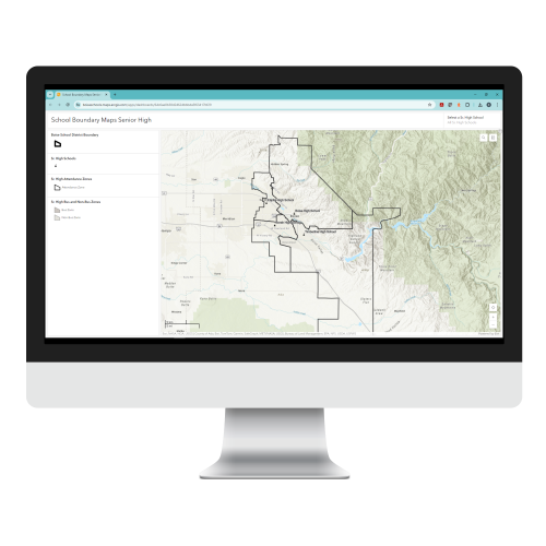
Boise School District
Modern GIS for better attendance zone and bus boundary management
Boise School District (BSD) tracked and managed school attendance zone boundaries, routed buses, and determined student eligibility to ride buses using a local GIS. But with zone boundaries changing frequently and its systems not keeping up, the District became overwhelmed with managing the high volume of complex GIS data and keeping it updated.
Resource Data replaced the old PDF maps BSD was relying on with online, interactive maps for school zones, from elementary to high school. We built an automated process to determine student eligibility for riding buses, wrote custom scripts to automate internal processes, and upgraded the District’s GIS to the latest enterprise software. These modern and reliable systems have helped BSD staff manage and update GIS data efficiently. It’s also easier for parents to check whether their kids are eligible to ride the bus to and from school.

National Oceanic and Atmospheric Administration (NOAA)
ORCA app changes the game for fisheries observers
On a boat in the rolling Pacific, obtaining clear and complete data with just pencils and paper poses a significant challenge. Despite this, NOAA Fisheries-trained observers on fishing vessels were successfully gathering essential scientific data using these traditional methods—but it was time consuming and difficult.
The West Coast Region Observer Program and Resource Data revolutionized marine data collection through the development of the Onboard Record Collection App (ORCA), a tablet-based application designed specifically to withstand temperamental at-sea conditions. Information integral to ensuring the sustainability of fisheries is now gathered and reported more efficiently, significantly saving time and improving data quality for precise reporting.

Tasha Jackson
Service Area Lead, GIS
Tasha leads the delivery of innovative geospatial solutions for clients across all industries. Known for her technical excellence and strategic vision, Tasha has over 15 years of experience managing complex GIS and IT initiatives across industries, such as oil and gas, utilities, and state and local government. She is an expert at understanding our clients’ business objectives and guiding organizations through the practical use of GIS tools and products to make informed decisions.
Tasha’s expertise spans GIS solution design and architecture, spatial analysis, enterprise system integrations, and data governance. With a strong foundation in geography and natural resource management from Western Washington University, she combines academic rigor with a practical, solutions-oriented approach. Tasha leads with collaboration and innovation, directing project teams to deliver impactful, user-centered geospatial products. Under her leadership, Resource Data continues to set the standard for delivering GIS services which support our client’s strategic business goals.
Our GIS Services
Chart your course with GIS.


Talk to Tasha Jackson

"*" indicates required fields
What happens
next?
- We'll schedule a conversation
- Share your challenges and goals
- Plan your journey together