Expertise
Discover the right GIS solution. The possibilities are endless.
We’ll set you up with the geospatial tools you need for success. From modifying your existing technologies or developing custom tools to creating interactive dashboards and integrating GIS with other systems, Resource Data is your GIS partner so you can focus on what matters most.
Custom Geospatial Solutions
Get custom GIS tools that fit your business’ specific and unique needs. Our experts build web apps, portals, dashboards, widgets, and more for your preferred online or offline devices. Avoid unnecessary costs and eliminate time-consuming workarounds. You can get exactly what your team requires without having to subscribe to a larger commercial software.

GIS Software Configuration
Whether it’s a low-code platform or custom solution, we install and configure your geospatial apps, tools, and widgets to streamline workflows and boost productivity. Our team will train your staff on the key features to maximize efficiency, reduce downtime, and eliminate frustration. With GIS software configured to your specifications, you can save time and focus on your business.
Location-Based Intelligence
With intuitive tools and dashboards that deliver location-based insights, you can easily track daily operations, align teams, and keep communities informed. We build solutions that deliver interactive, map-centric metrics and KPIs integrated with your workflows and business processes. Customize dashboards and reports to your audiences for at-a-glance decision making.

Systems Integration
Are your teams struggling to link GIS and business data? Is valuable GIS information overlooked because your systems don’t communicate? We’ll connect separate systems and data warehouses or simplify complex integrations so you can discover patterns and relationships for clearer insights and confident decision making.
Business Process Improvement
Unlock your team’s potential with GIS tools that improve the way your organization operates. Our teams analyze your workflows to identify inefficiencies. Then we configure GIS applications for efficient operations, providing a seamless experience across your organization.

Our Clients
Hundreds of clients. Thousands of GIS projects.


I appreciate the level of professionalism and technical expertise that Resource Data provides. They work hard to understand our needs and circumstances. The team is really good at remembering all the details and bringing them back up to ensure nothing falls through the cracks.
~ Nils Andreassen, Executive Director, Alaska Municipal League
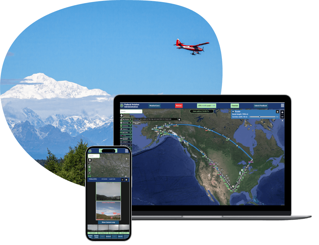
Federal Aviation Administration
A powerful web tool improves aviation safety and reduces costs
Pilots in Alaska often fly in remote locations and in severe weather patterns, facing higher risks of accidents and flight interruptions. Resource Data partnered with the Federal Aviation Administration (FAA) to build a new version of its weather camera website, giving pilots access to real-time imagery and accurate weather information from live camera feeds. The new site, weathercams.faa.gov, makes a wealth of complex information quickly accessible and understandable to pilots before and during flights, improving flight decision making and aviation safety.
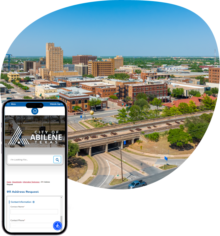
City of Abilene
911 Addressing solution expedites address allocation
Cities and counties nationwide rely on accurate 911 response and addressing systems to ensure emergency responders know exactly where to go. When the City of Abilene, a mid-size city in Texas, was down to a single GIS staff member, a significant backlog of critical 911 addressing requests accumulated.
Our team of GIS experts was called in to address the backlog and streamline the request submission and management processes. By implementing Esri’s Survey 123 and Experience Builder, we replaced the time-consuming and error-prone process with a more efficient and user-friendly solution.
Address processing times were cut by 50%. These new tools not only improved the City’s operational workflows but also simplified the process for public users who now submit 90% of their requests online.
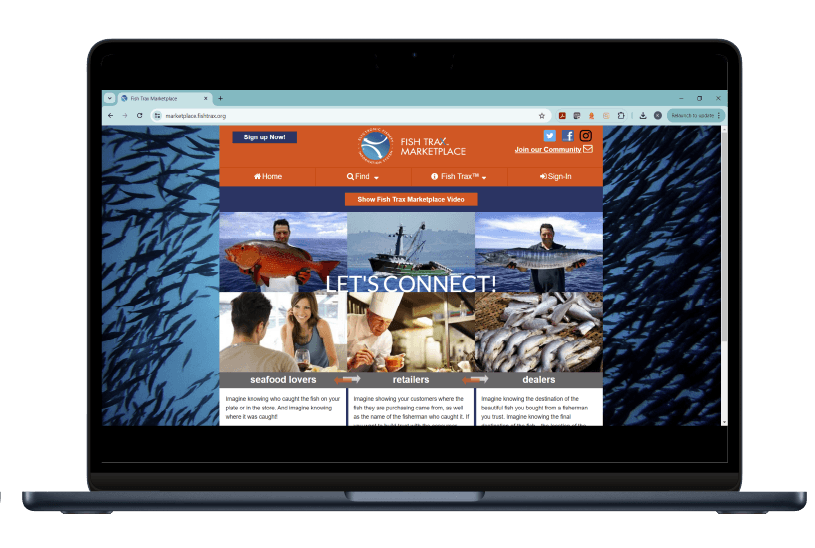
Oregon Salmon Commission
Mobile fish tracking system for fisheries management
Collecting accurate information from commercial fishing catches is crucial to promoting sustainable fishing practices. But extreme conditions at sea made it difficult for fishers to collect and share reliable data.
Working with the Oregon Salmon Commission, Resource Data developed Fish Trax—a custom mobile application designed to withstand extreme environments—and integrated it with a full website and web service for plotting, archiving, and analyzing fishing trips and commercial catches. The application’s powerful mapping capabilities and near-real-time data collection replaced outdated and unreliable methods to collect and share data. Fisheries managers, scientists, regulators, and marketers use these tools for enhanced data analysis, collaboration, and data-driven decision making.
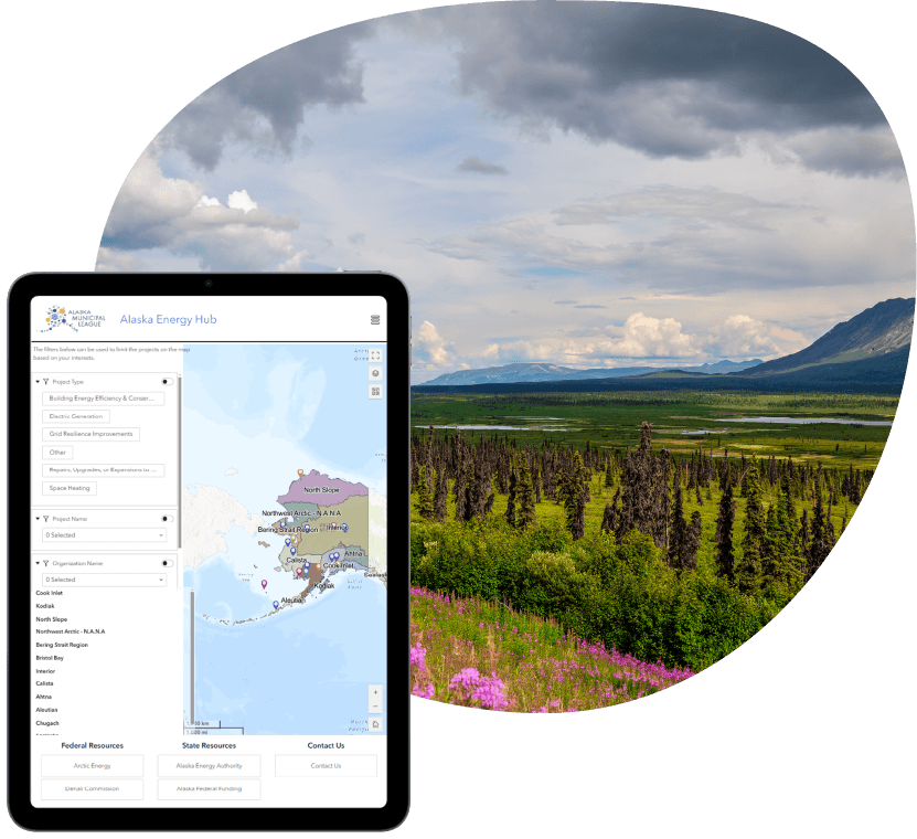
Alaska Municipal League
A GIS solution to help fund critical energy infrastructure project
The Alaska Municipal League (AML) is a nonprofit organization of 165 Alaska cities, boroughs, and unified municipalities. To support the infrastructure and energy needs of these communities, AML needed a simple solution to connect their members with resources and agencies that provide funding and technical assistance for important energy projects
Resource Data created the Alaska Energy Hub, an ArcGIS Online-based GIS solution. The Hub features a public-facing website, interactive tools, and project-submission surveys. It includes an administrative component for AML staff to review, edit, and manage energy project locations and details efficiently. Our work also supported AML’s Arctic Energy Ambassadors initiative, connecting local champions with stakeholders to drive regional and statewide energy projects. Within the first year, the website drew nearly 10,000 views and facilitated 25 energy project submissions.
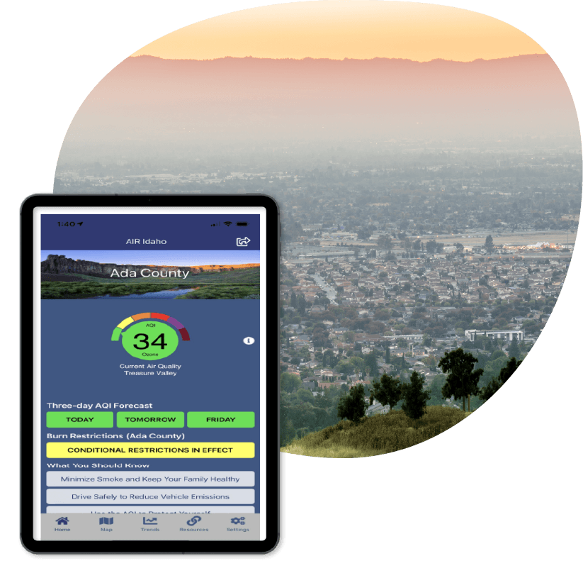
Idaho Department of Environmental Quality (IDEQ)
Easily communicating air-quality and safety information
IDEQ monitors Idaho’s air, land, and water quality to protect public health. They needed a user-friendly solution to provide air-quality and related safety information to Idaho residents, especially during times of poor air quality.
Resource Data developed the AIR Idaho mobile app, which harnesses GIS to give users access to near real-time information on nearby air quality. It features air-quality forecasts, an interactive map displaying data from over 30 monitoring stations across the state, information on burning restrictions, and more. We deployed the application on Apple and Android platforms, provided user and application guides, and ensured the app was running smoothly.
AIR Idaho connects Idaho residents to the latest air-quality and safety information, empowering them to protect their health. By featuring tips to contribute to safer air quality, the app also promotes public awareness of individuals’ environmental impact.
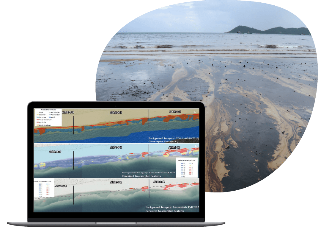
Major Oil and Gas Company
Custom GIS for successful incident response
When a major oil spill occurred in the Gulf of Mexico, the client needed to know where and how the oil was spreading, how it was impacting the environment, and which resources were available to respond. Resource Data led the GIS response team and built custom web and mobile apps that provided spatial information crucial to guiding clean-up efforts and evaluating the effects to the Gulf’s natural resources.
The applications helped coordinate around-the-clock spill response work by BP, the U.S. Coast Guard, NOAA, the EPA, four state agencies, and multiple contractors successfully. The field data became more accurate and was used daily to support the ongoing response and meet federal reporting requirements. More than 50,000 National Resource Advisor reports were filled out and gathered during the response effort. And over 1,000 people used our applications throughout the cleanup.
Real-World Solutions
Invaluable Insights. From Anywhere.
See how GIS solutions can help you collect and analyze data, simplify your operations, and unlock valuable location-based insights—whether out in the field or in the office.
Incident Response
Prepare for emergencies with disaster-response systems that enable interactive, real-time data gathering, processing, and sharing among users. GIS provides emergency planners and responders with critical location and population-specific data, aiding coordination efforts before, during, and after disasters. From mapping hazards and tracking storms to assessing infrastructure damage, GIS tools have the features you need.
Community Engagement
Looking to gather input and ideas from the public for community initiatives, grant funding, and more? We build and configure user-friendly GIS apps and tools that clearly communicate complex data through maps, 3D modeling, and GPS. These easy-to-use tools increase community engagement and help improve data-driven decision-making.
Mobile Data Collection & Reporting
Leverage spatially enabled apps to simplify real-time data collection, storage, and processing across teams and institutions, no matter their location. Our GIS data-collection and reporting apps work seamlessly offline, support all major mobile platforms, and minimize errors while boosting efficiency.
Field Operation Apps
Is your team still using paper and clipboards for field-data collection? Eliminate tedious data entry and reporting delays. Improve your processes and enhance collaboration by upgrading to a more efficient, effort-free system with a custom GIS app built specifically for your team.


Tasha Jackson
Service Area Lead, GIS
Tasha leads the delivery of innovative geospatial solutions for clients across all industries. Known for her technical excellence and strategic vision, Tasha has over 15 years of experience managing complex GIS and IT initiatives across industries, such as oil and gas, utilities, and state and local government. She is an expert at understanding our clients’ business objectives and guiding organizations through the practical use of GIS tools and products to make informed decisions.
Tasha’s expertise spans GIS solution design and architecture, spatial analysis, enterprise system integrations, and data governance. With a strong foundation in geography and natural resource management from Western Washington University, she combines academic rigor with a practical, solutions-oriented approach. Tasha leads with collaboration and innovation, directing project teams to deliver impactful, user-centered geospatial products. Under her leadership, Resource Data continues to set the standard for delivering GIS services which support our client’s strategic business goals.


