



WeatherCams: Near Real-Time Data for Safer Flights
In Brief
A powerful web tool improves aviation safety and reduces costs
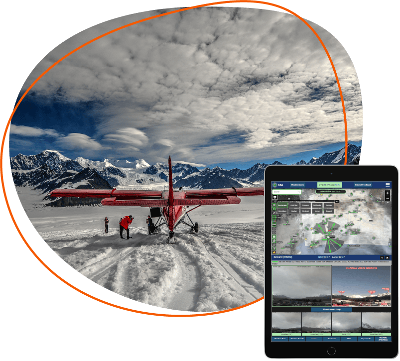
Pilots in Alaska often fly in remote locations and in severe weather patterns, facing higher risks of accidents and flight interruptions. To improve aviation safety, the Federal Aviation Administration (FAA) initiated a successful weather camera program in 1999 which gave pilots access to weather data and live-camera feeds.
Two decades later, they partnered with Resource Data to build the next generation of their weather camera website. The new site, weathercams.faa.gov, is a progressive web app that makes a wealth of complex information quickly accessible to pilots before and during flights. It receives over 230 million hits per year by pilots who rely on it to make safe aviation decisions.
Key Takeaways
Timely, accurate weather information saves lives and cuts costs in the world of aviation
-
Complete flight solution for holistic view
With access to more data than before, the new FAA WeatherCams site equips pilots with a holistic view that includes advisory weather reports, aeronautical charts, and more.
-
Near real-time imagery for better preflight planning
The camera images provide multiple views at each location and update every 10 minutes. This means pilots assess routes before flying based on accurate information to avoid potential hazards and unnecessary operational costs.
-
Cloud technology for load balancing
FAA WeatherCams was built using the latest cloud technologies, making the website fast and scalable to accommodate thousands of simultaneous users.
-
Pilot-centric design for information at a glance
FAA subject matter experts, pilots, and human factor experts guided the user interface design, ensuring data, terminology, and symbology are familiar to pilots.
-
Real aviation safety results support rapid expansion
Over a seven year period, FAA saw a 69% reduction in weather-related flight interruptions and 85% reduction in weather-related aviation accidents. Following Alaska’s success, the FAA has rapidly extended the program and now uses more than 600 camera sites throughout North America.

The Challenges
Website integral to aviation safety in need of modernization
Alaska spans 586,412 sq. miles with 33,904 miles of coastal land. With 82% of communities lacking road connections, planes are a vital form of transportation. It is critical for pilots to be able to access accurate weather information and imagery across the state, especially in remote areas where there are no routine weather-reporting facilities or systems. The FAA began its weather camera program in Alaska in 1999 to provide supplementary information to pilots.
Camera services proved so successful at reducing weather-related aviation accidents the system quickly grew to more than 230 camera sites; many were in remote locations such as mountain passes where weather can create a chokepoint and coastal areas where fog routinely interferes with Visual Flight Rules (flying based on visual observation of the terrain).
Over time, the FAA recognized the need to enhance the weather camera program’s effectiveness and ease of use for pilots. Their goal was to provide more data while ensuring optimal site performance across various devices. To achieve this, the legacy website needed to be rebuilt leveraging modern technologies.
Our Approach
A pilot-centric approach built on collaboration
Resource Data worked closely with FAA subject matter experts and pilots for several years to design the interactive WeatherCams website specifically for pilots. An agile approach allowed us to closely collaborate with a human factors’ expert from the FAA. They provided expertise regarding how pilots interact with cockpit systems and pre-flight planning data.
This expertise combined with live testing by Alaska pilots, helped guide the user-interface design and ensured the data, terminology, and symbology was the most effective and efficient way to present crucial information to pilots.
Solution
Robust preflight planning tool allows pilots to “Look Before they Fly”
The new website is now a comprehensive system with enhanced weather data and an improved user interface that conveys conditions more effectively at a glance. The Progressive Web App (PWA) uses React and other modern front-end frameworks that load large amounts of data quickly and work well on mobile and desktop devices. The backend is a Node.js-driven platform that aggregates data from many other sources and provides it through a REST-ful API.
We also implemented a cloud-native architecture, using serverless platforms, micro-services, cloud SQL, Docker containers, and Terraform to create a platform that is fast, reliable, scalable, and easy to deploy. The upgraded system takes advantage of modern cloud-based technologies, which positioned the FAA to expand the system beyond Alaska in support of aviation safety throughout North America.
Features
Providing pilots with critical data in a user-friendly and powerful web app
-
Interactive map and advanced search for quick access to data
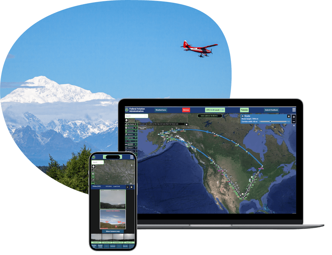
Clickable weather camera icons and advanced search features allow users to easily find weather camera locations and view images for easier route planning.
-
Saved routes for future reference
Pilots sketch prospective flight paths directly on the map then view all pertinent weather information along their chosen route. Routes are saved for future use, allowing quick and comprehensive evaluation of flight plans.
-
Camera loops for identifying trends
Cameras show current sky condition and visibility using reference features. The camera loop lets users see the past six hours of images to spot trends and check if the current weather matches forecasts.
-
Toggled information layers for easy info consumption
Toggled information layers display key information at high zoom levels and more details when the user zooms in. This intuitive user experience combined with a decluttered map make inflight weather monitoring easy.


“Our mission is to improve aviation safety and efficiency within the NAS [National Airspace System] and reduce weather-related accidents and flight interruptions. We do that by getting a near real-time picture of the weather into the pilot’s hands prior to flying.”
- Cohl Pope, FAA Weather Camera Program Manager
Results
Changing the nature of flight planning and decision making
The new weather camera site, weathercams.faa.gov, provides the exact data pilots need, using a display and terminology familiar to them, to make informed route planning and go, no-go decisions. Everything from symbol placement to the colors used, makes complex information quickly accessible and understandable before and during flights.
It plays a critical role in in preflight planning and inflight monitoring of weather at airports and en route locations. The website receives over 230 million hits per year and continues to yield amazing results, reducing weather-related flight interruption hours and aviation accidents.
“The weather cameras have been a game changer in Alaska.”
- Eric Albrecht, Operations Support Manager for Alaska Flight Services
What's Next
Building a nationwide network of weather cameras
Following the success of Alaska’s WeatherCams program, the FAA expanded the program from 230 camera sites in Alaska to 600 throughout North America. They have plans to add 160 new camera sites through fiscal year 2030. The new site was built to scale to support these plans.
Resource Data continues to work closely with the FAA as they expand the WeatherCams program. New feature development continues to provide pilots with more weather data, delivered in near real-time; enhance data quality; and accomodate more camera sites and more users.




Case Study FAQ
Near-real-time weather camera data improves aviation safety by giving pilots a direct visual check of current conditions before they commit to a route. In remote areas, where routine weather reporting facilities may be limited or unavailable, camera imagery can help pilots identify fog, visibility changes, mountain pass conditions, and other hazards that may not be obvious from text reports alone.
In Resource Data’s FAA WeatherCams case study, the Federal Aviation Administration’s (FAA’s) weather camera program began in Alaska to help pilots access weather data and live camera feeds. Resource Data later helped build the next generation WeatherCams website so pilots could access near-real-time images, advisory weather reports, aeronautical charts, and other preflight planning information from more devices.
By helping pilots “look before they fly,” WeatherCams supports safer go/no-go decisions, reduces uncertainty in severe or fast changing weather, and contributes to fewer weather-related flight interruptions and aviation accidents.
A pilot centered weather website matters because flight planning is a time sensitive decision process in which information has to be accurate, familiar, and easy to interpret quickly. A site can contain valuable data and still fail pilots if the display, terminology, symbols, or mobile experience make conditions hard to understand at a glance.
Resource Data’s case study shows how the user experience was shaped around pilots rather than around generic web design. FAA subject matter experts, pilots, and a human factors expert helped guide the interface design, including the data, terminology, symbology, colors, and placement of information. Live testing by pilots flying in Alaska also informed the effort.
When pilots can interpret complex aviation weather information faster, a website becomes a practical safety tool rather than just a data portal. That supports more efficient preflight planning and helps reduce avoidable risk before and during flights.
Aviation agencies can reduce weather related flight interruptions by making current conditions easier to verify before pilots take off. That means combining camera imagery, weather reports, route context, maps, and location search into a tool that helps pilots compare forecasted conditions with what is happening on the ground.
In Resource Data’s WeatherCams case study, the upgraded website includes camera loops showing images from the past six hours, interactive map access, advisory weather reports, aeronautical charts, saved routes, and information beyond METAR data. These features help pilots assess whether conditions are improving, worsening, or matching the forecast along a planned route.
Better preflight visibility can reduce unnecessary departures, diversions, delays, and interruptions, while helping pilots proceed when conditions support a safe flight.
Making complex aviation weather information easy to understand requires careful user interface design. Pilots need the right information hierarchy, familiar aviation terminology, clear symbology, map context, and device friendly interactions so they can interpret conditions quickly under real world time pressure.
In Resource Data’s case study, the design process was guided by FAA subject matter experts, pilots, and human factors expertise. The site uses interactive weather camera icons, toggled information layers, decluttered map views, zoom based detail, and familiar colors and symbols to help pilots understand conditions efficiently.
When the interface reduces visual clutter and presents aviation data in a pilot friendly way, users spend less time hunting for information and more time making informed safety decisions.
A camera loop helps pilots make better weather decisions by showing how conditions have changed over time, not just what one camera frame looks like at a single moment. Trend information matters because weather can shift quickly in mountain passes, coastal areas, and other challenging flight environments.
In Resource Data’s case study, the WeatherCams site includes a camera loop that lets users view images from the past six hours. This helps pilots identify trends and decide whether current weather aligns with forecasted conditions. It also gives more context than a static image or text only weather report can provide.
The operational impact is risk reduction and better route planning. Pilots can use visual trends to recognize worsening visibility, improving conditions, or persistent hazards before takeoff. This supports safer and more efficient flight decisions.
Saved routes are useful because pilots often need to evaluate weather across an entire planned flight path, not at one camera location. A route based view helps pilots focus on the locations and conditions most relevant to the trip they are preparing to fly.
Resource Data’s WeatherCams case study describes the “My Routes” feature, which lets pilots highlight weather information on a planned route and save routes for future reference. This makes it easier to reassess the same flight path before takeoff without rebuilding the view each time.
Pilots can return to known routes, compare conditions more efficiently, and make faster decisions using weather information that is already organized around their flight plans.
A public aviation website can serve professional pilots and broader users by prioritizing the safety critical workflow first, then making the information accessible enough for other valid uses. Aviation weather tools need to be precise for pilots, but clear imagery, maps, and location based weather views can also help people outside aviation understand remote conditions.
In Resource Data’s case study, the primary audience is pilots who use WeatherCams for preflight planning and aviation safety. However, the case study notes that the site is also useful for planning recreational activities such as skiing and climbing, and that climatologists may use camera images to measure melting snowpack and support weather and water demand forecasts.
The business impact is broader public value from the same digital infrastructure. A well designed government data platform can support its core safety mission while also creating secondary benefits for recreation, research, and environmental planning.
A progressive web app (PWA) is a strong fit for an aviation weather platform because pilots need fast, reliable access across mobile and desktop devices without a clunky device with specific experience. A PWA can deliver apps like usability through the web while supporting large amounts of dynamic data.
Resource Data’s case study explains that the new weathercams.faa.gov site is a PWA built with React and modern front end frameworks. It was designed to load large amounts of data quickly and work well on mobile and desktop devices, so pilots have easier access to more information than the legacy website could provide.
Pilots can use the same, modern weather planning tool across devices, which improves usability and supports more consistent decision making before flights.
A weather camera website that supports thousands of simultaneous users needs a scalable cloud architecture, efficient data services, and deployment practices that can handle heavy demand without slowing down access to safety critical information. Performance matters because pilots rely on the site to make timely decisions.
Resource Data’s case study explains that the solution’s backend is a Node.js-driven platform that aggregates data from many sources and provides it through a RESTful API. Resource Data also implemented a cloud native architecture using serverless platforms, microservices, cloud SQL, Docker containers, Terraform, Redis, PostgreSQL with PostGIS, and Google Cloud Services.
The WeatherCams site receives more than 230 million hits per year, so the platform needs to remain fast and available as usage grows, and more camera sites are added.
System integration improves an aviation weather camera platform by bringing camera imagery, advisory weather reports, aeronautical charts, location data, and route context into one usable experience. For pilots, the value comes from seeing related information together instead of checking disconnected sources under time pressure.
Resource Data’s WeatherCams case study describes a backend platform that aggregates data from many other sources and exposes it through a RESTful API. The website combines near real time images, map interactions, advanced search, camera locations, route tools, and weather information beyond METAR data.
Pilots can assess conditions from a more complete picture, and the FAA gains a more extensible platform for adding new data sources, camera sites, and capabilities over time.
Cloud modernization can help a government website expand from a regional tool to a national platform by making the system easier to scale, deploy, maintain, and extend as user demand and geographic coverage grow. A regional safety tool may need to support many more locations, users, and integrations once it proves successful.
In this case study, the original weather camera program began in Alaska, where aviation depends heavily on accurate remote weather information. The upgraded WeatherCams platform uses modern cloud based technologies and is positioned to expand beyond Alaska to support aviation safety throughout North America. The program has grown to more than 550 North American camera sites, with expansion continuing into Hawaii, Colorado, and many other states.
Cloud modernization helps the FAA continue adding camera sites and features without treating each expansion as a separate technology rebuild. This improves time to value and supports a growing aviation safety network.