


Streamlining Fisheries Data Collection with ORCA: An App Built for At-Sea Conditions
In Brief
ORCA app changes the game for fisheries observers
On a boat in the rolling Pacific, obtaining clear and complete data with just pencils and paper poses a significant challenge. Despite this, NOAA Fisheries-trained observers on fishing vessels were successfully gathering essential scientific data using these traditional methods—but it was time consuming and difficult.
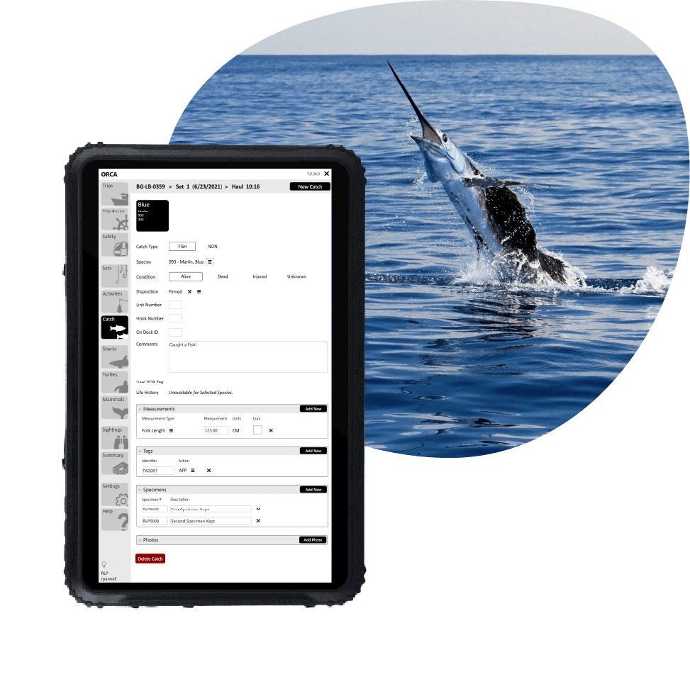
The West Coast Region Observer Program and Resource Data revolutionized marine data collection through the development of the Onboard Record Collection App (ORCA), a tablet-based application designed specifically to withstand temperamental at-sea conditions. Information integral to ensuring the sustainability of fisheries is now gathered more efficiently, significantly saving time and improving data quality for precise reporting.
Key Takeaways
Streamlined marine data collection with a thoughtfully designed app
-
Digital data collection for enhanced data integrity
By transitioning from paper-based to digital forms, ORCA reduces human error, ensures consistency across data points, and improves the reliability of data collected at sea.
-
UX/UI designed for use in harsh weather conditions
ORCA’s tile-like design and adaptable display modes minimize the challenges posed by at-sea conditions. A touch-friendly interface enables quick, error-free data entry, even while wearing gloves.
-
Built-in functionality for ease and accuracy
The addition of GPS functionality, automatic time-stamping, and simplified image capturing directly tackles previous logistical hurdles, enhancing the precision of location and species identification data.
-
Touchscreens for streamlined data entry
The app’s streamlined processes significantly reduce the time required for data entry and submission. Observers seamlessly shift between digital fields instead of paper forms, allowing more focus on observation and less on paperwork.
-
Scalable and adaptable for broader application
Since ORCA’s successful implementation, it’s been deployed and customized for other Observer Programs, including NMFS Pacific Island Regional Office.
The Challenges
Traditional paper-based data collection risks inaccuracy and wastes time
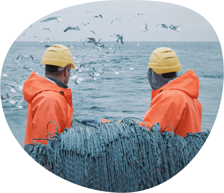
The West Coast Region Observer Program (WCROP) assigns NOAA Fisheries-trained observers to fishing vessels to collect data and monitor the incidental capture of marine mammals, sea turtles, and seabirds. Observers record fishing activity, gear setup, and the catch and disposition of both target and non-target fish species, along with collecting biological samples for studies and stock assessments. This information is crucial for fisheries sustainability.
A new standard deep set buoy gear targeting swordfish and reducing bycatch in the West Coast and California ecosystem prompted innovation. Observers, using traditional paper forms ill-suited for the at-sea environment with its high winds and rolling seas, had only seconds to record interactions. They shuffled through different waterproof paper forms, and once ashore, they faced a lengthy process of delivering forms to the program office and manually entering data into a computer.
Observers required a digital solution robust enough for the marine environment to simplify data recording at sea. The need to avoid data loss and inaccuracies from traditional methods also led to a push for technology transformation.
The Solution
An app with UX/UI designed for extreme weather conditions
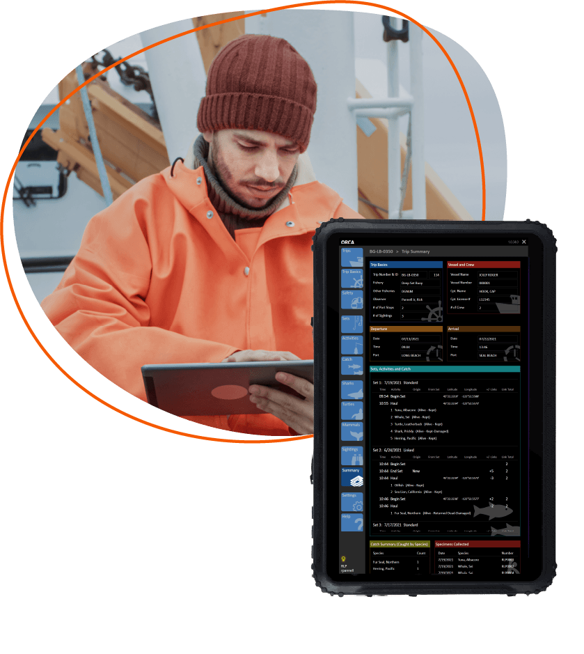
The ORCA app, a robust and intuitive tablet application, seamlessly phased out traditional paper-based methods for recording data on fishing activities, bycatch, and marine sightings.
Our approach was rooted in a user-centric design philosophy, involving Observers in the development process to ensure the app stands up to the stringent requirements of at-sea data collection and guarantees efficiency and reliability.
Features
Built-in Efficiencies Save Time for Observers, Vessel Crew, and NOAA Fisheries
-
Touch-oriented tiles for quick and easy data entry
Large, accessible tiles with images and text, allows observers to quickly navigate through multiple forms and capture data quickly.
-
Adaptable display modes for usability in any weather
ORCA features adjustable brightness levels and display modes to ensure visibility across varying weather conditions. Dark mode, for example, reduces glare and allows observers to view their screens in bright, sunny conditions.
-
Intelligent form inputs for speed and accuracy
The app’s smart form features include touch data selection, drop-down options, and pre-filled trip data, allowing Observers to move faster through the data entry sequence while reducing errors.
-
GPS receiver for location-based intelligence
To link accurate location information with fisheries data while offline, ORCA integrates with a built-in GPS receiver in the rugged, waterproof tablets.
-
Built-in camera integration for easier observation
Observers no longer need to reach for a separate device to take a picture for later review and identification. Built-in cameras make it easy to take a picture and immediately link it to the right observation and form.
-
Offline operation and automated synchronization for streamlined processes
The app pre-loads trip data, including data from previous trips, ensuring information is accessible while offline. New data collection synchs when Internet becomes available.
“The more you can shorten the path between the data entry method and the database, the less likely you are to end up with inaccurate or bad data. You cut out those quality control slips. Observers can now spend more time on biological sampling and not worry about data forms getting soaked or blown away. It’s so much easier and efficient.”
- Jody Van Niekerk, ORCA Project co-lead & Biologist, NOAA Fisheries West Coast Region
Results
Expanding ORCA's reach to foster easier ecosystem management
ORCA and its corresponding reporting system replaced manual, error-laden processes saving time for observers and NOAA Fisheries staff. The app makes it easier to consolidate data for reporting and increases Observer Program data integrity. The app’s effectiveness as a data collection and reporting tool facilitated its adoption by additional fisheries.
Through connections forged while developing ORCA, including Pacific States Marine Fisheries Commission (PSMFC) and Pacific Fisheries Information Network (PacFIN), Resource Data designed and implemented a new version of ORCA for the Pacific Islands Regional Observer Program (PIROP) for the pelagic longline fisheries. Both PIROP and WCROP currently share the ORCA application, facilitating data entry by observers from both programs.
“The tablets definitely make our job a lot easier in terms of organization and keeping track and getting information down correctly.”
~ Matthew Speegle, NOAA Fisheries Observer
What's Next
Setting the new standard in marine data collection
The vision is for ORCA to become a standard tool in marine data collection and reporting, fostering better ecosystem management through advanced technology.
We continue to provide ongoing support and enhancements. The immediate strategy involves merging the two versions of ORCA into a single code base, making it more adaptable for multiple fisheries and agencies in the future and facilitating better data sharing across NOAA and other fisheries organizations.

Case Study FAQ
A tablet based data collection app can improve fisheries observer programs by replacing paper forms with structured digital workflows that are faster, more consistent, and easier to connect to reporting systems. For observers working at sea, the right app reduces paperwork friction while helping protect the quality of scientific data.
In Resource Data’s case study, the West Coast Region Observer Program and Resource Data worked together to develop the Onboard Record Collection App (ORCA) for NOAA Fisheries trained observers on fishing vessels. ORCA moved data collection for fishing activity, bycatch, marine sightings, and biological sampling from paper forms to rugged tablet workflows built for at-sea conditions.
Observers can spend less effort managing forms and more time collecting accurate information needed for fisheries sustainability, stock assessments, and ecosystem management.
Digital data collection is important for fisheries sustainability because management decisions depend on complete, accurate, and timely field data. When observers record fishing activity, target and non-target catch, protected species interactions, and biological samples, even small errors or delays can affect reporting and analysis.
Resource Data’s ORCA case study shows how paper forms create risk in harsh at sea environments. Observers had only seconds to record interactions, worked with waterproof forms in high winds and rolling seas, and later had to deliver forms to the program office for manual data entry. ORCA shortened the path between data entry and the database.
The business and operational impact is stronger in data integrity. By reducing manual transcription, lost forms, and inconsistent entries, ORCA helps NOAA Fisheries record more reliable information for reporting, science, and sustainable fisheries management.
Digital tools save time by reducing the number of manual steps between field observation, form completion, quality control, and reporting. When observers can enter data directly into a structured app, program staff spend less time interpreting paper records and reentering information after a trip.
In this case study, ORCA replaced manual, error prone processes with tablet based data collection and a corresponding reporting system. NOAA Fisheries noted that observers could spend more time on biological sampling instead of worrying about soaked or windblown forms, and the app made it easier to consolidate data for reporting.
The operational impact is faster collection and reporting. Observers, vessel crews, and NOAA Fisheries staff benefit from less paperwork, fewer quality control slips, and more efficient movement of data from the vessel to program systems.
A data collection app is usable in harsh marine conditions when it accounts for weather, motion, glare, gloves, limited time, and offline operation. At sea, a normal office style form can be too slow or fragile; observers need large touch targets, clear display modes, simple navigation, and workflows that match the pace of deck activity.
In Resource Data’s case study, ORCA was designed with a tile like interface, adjustable brightness, display modes such as dark mode, and touch friendly navigation. Observers were involved in development, so the app could stand up to stringent at-sea requirements and support quick data entry, even in difficult weather.
Outcomes include fewer entry mistakes and better field usability. A design built for the marine environment helps observers capture accurate information when they have only seconds to record an interaction.
Touch oriented tiles improve observer data entry by making forms easier to navigate quickly on a rugged tablet, especially when users are moving, wearing gloves, or working in wet conditions. Large visual controls reduce the need for precise typing and help observers shift between data fields more efficiently.
This case study describes large, accessible tiles with images and text that help observers navigate multiple forms and capture data quickly. The interface was built around real observer workflows rather than simply digitizing paper forms.
Observers can focus on the biological event or fishing activity in front of them instead of fighting with small controls or shuffled paper forms.
Offline operation matters because observers on fishing vessels cannot rely on constant internet access. A fisheries data collection app needs to preload trip information, let observers record new observations without connectivity, and synchronize the data when a connection becomes available.
In Resource Data’s case study, ORCA preloads trip data (including data from previous trips) so that information is available offline. New data collection synchronizes when internet access becomes available, allowing observers to keep working in real at-sea conditions.
This app’s functionality improves continuity and data protection. Observers do not have to pause data collection because a vessel is offline, and the program can still move data into reporting workflows once connectivity returns.
GPS and camera features improve data quality by linking observations to more precise location and visual evidence when the data is collected. That reduces the need for separate devices and helps connect each observation to the right form, place, and biological context.
The ORCA case study highlights GPS functionality, automatic time stamping, and built in camera integration. ORCA uses the GPS receiver in rugged, waterproof tablets to connect location information with fisheries data while offline and built in cameras let observers attach images to the correct observation for later review and identification.
Location, time, and image context help improve species identification, reporting accuracy, and the scientific value of observer data.
User centered design improves public sector scientific software by making sure the tool works in the real environment where data is collected, not just in an office or development setting. For field programs, the software must reflect user constraints, mission requirements, and the consequences of inaccurate data.
In this case study, observers were involved in the development process so the app could meet the requirements of at-sea data collection. Resource Data’s approach focused on usability, reliability, and efficiency for NOAA Fisheries trained observers collecting sensitive scientific and monitoring data.
This approach improved app adoption and lowered risk. When software is built around real field conditions, users are more likely to trust it, use it correctly, and produce consistent data for program reporting.
Shortening the path between data entry and the database improves data quality by reducing transcription steps, delays, and opportunities for quality control errors. Every manual handoff from paper to office processing creates a chance for lost, incomplete, or misread information.
In the ORCA case study, NOAA Fisheries ORCA project co-lead Jody Van Niekerk explained that the shorter the path between the data entry method and the database, the less likely the program is to end up with inaccurate or bad data. ORCA replaced paper forms and manual entry with direct digital collection and synchronization.
Data can move from observer entry to program systems with less manual handling, which supports faster consolidation and stronger fisheries for data integrity.
Agencies replacing paper field forms with an app should consider field conditions, user workflow, offline access, and device durability. They should also have data validation, reporting needs, and how the app will connect to existing databases in mind. A successful replacement should simplify the work instead of recreating paper forms on a screen.
This case study shows several of these considerations in practice. ORCA was built for rugged waterproof tablets, with touch friendly tiles, adaptable display modes, smart form inputs, prefilled trip data, GPS, camera integration, offline operation, and automated synchronization.
The business impact is a smoother transition from paper to digital operations. Agencies can reduce errors and save time while giving field staff a tool that fits the physical realities of their work.
One field data collection app can scale across multiple fisheries programs when it has a flexible design, shared core workflows, and enough configurability to support different program requirements. Scalability depends on building a reusable foundation rather than a single purpose tool that only fits one fisheries organization.
In Resource Data’s case study, ORCA’s success with the West Coast Region Observer Program (WCROP) led Resource Data to design and implement a version for the Pacific Islands Regional Observer Program (PIROP) for pelagic longline fisheries. The case study states that WCROP and PIROP share the ORCA application, and future work focuses on merging versions into a single code base.
A shared, adaptable application can support multiple fisheries and agencies, reduce duplicated development effort, and help set a stronger standard for marine data collection.