
Interactive Web Map Clarifies Land Access and Supports Responsible Use
In Brief
Web Map Improves Public Awareness and Protects Shareholder Lands
Gana-A’Yoo, an Alaska Native Village Corporation owned by over 2,200 Koyukon Athabascan shareholders, needed a clear, accessible way for hunters and recreationists to understand where its corporate lands begin and what rules apply to their use.
Resource Data deployed a public-facing ArcGIS Online web map and QR-code access workflow that clarified boundaries and reduced unintentional trespassing during hunting season. The solution also strengthened Gana-A’Yoo’s internal land management capabilities for long-term resource planning and the protection of Athabascan cultural heritage.
Key Takeaways
A field-ready tool that removes guesswork.
-
Clear Land Boundaries Accessible to the Public
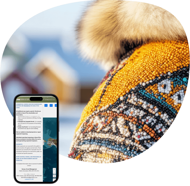
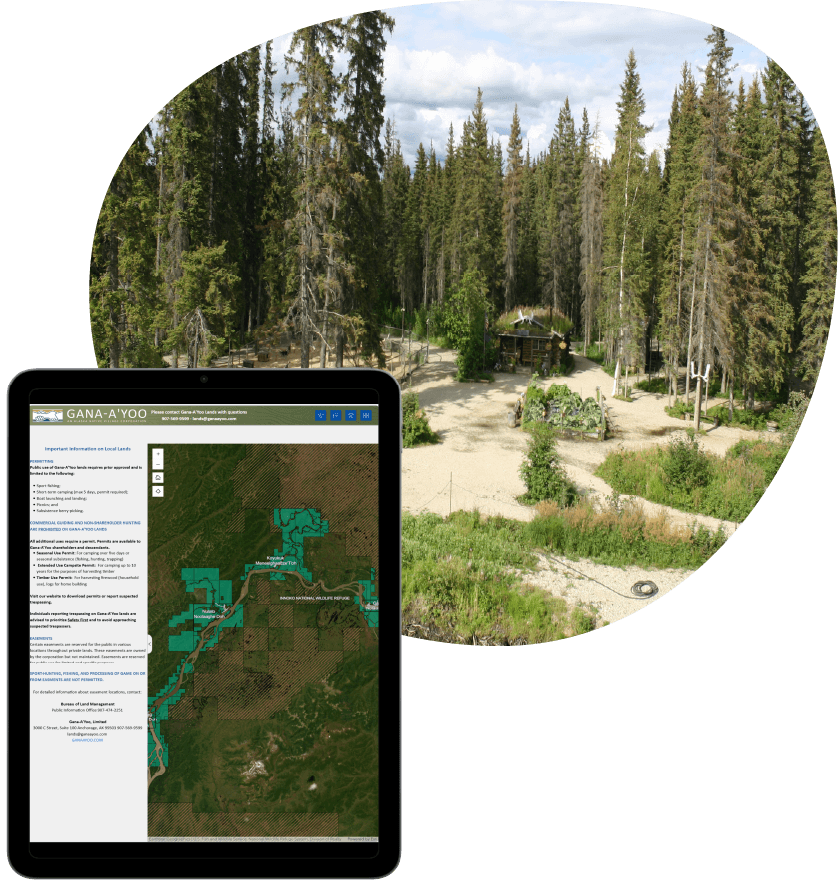
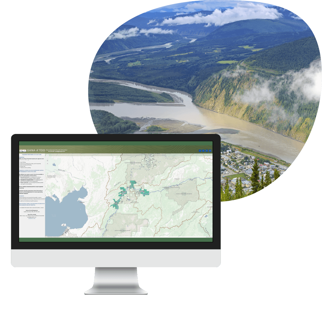
A mobile-friendly Experience Builder application enables recreationists and hunters to identify Gana-A’Yoo land, review access rules, and locate themselves on the map while in the field.
-
Rapid Delivery for Hunting Season Deadline
Leveraging publicly available data allowed the team to configure the AGOL environment, publish layers, and deploy the web map within the client’s expedited timeline.
-
QR Code Provides Immediate Field Access
A scannable QR code links directly to the public map and is placed on signs at the entrances to Gana-A’Yoo territory, allowing the public to quickly view land status while approaching or entering the area.
-
Internal Map Supports Long-Term Land Planning
A separate internal version provides additional layers—such as vegetative and biological data—that support land management, conservation insights, and long-term planning.
-
Culturally Aligned Cartography
Custom labels created with Arcade expressions display both common and Koyukon names for local communities, reinforcing cultural context within the map interface.

The Challenges
Manual review slowed enrollment and strained staff
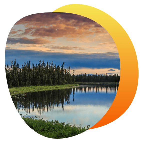
Gana-A’Yoo manages more than 438,000 acres of land across western Alaska where public access is limited to approved activities such as sport fishing, camping, and picnicking. Hunters and recreationists often struggled to identify these boundaries, leading to unintentional trespassing, improper land use, and growing safety concerns for nearby communities.
The corporation is also committed to protecting Athabascan cultural heritage and needed clearer geographic insight to guide land stewardship and conservation decisions.
With hunting season approaching, they sought a fast, accurate, and user-friendly mapping tool that could communicate land access rules and help reduce misuse.
The Solution
Web maps built for clarity, access, and stewardship
Resource Data configured an ArcGIS Online environment and built a public Experience Builder application using a combination of public and internal datasets. The map provides clear boundary visualization, rule information, pop-ups, and location tools so the public can easily understand where they stand relative to corporate lands.
A QR code placed on signs at the entrances to Gana-A’Yoo territory enables immediate access to the web map while on foot. Mobile and tablet layouts were configured and tested to ensure reliable field use, and users can view detailed land information, including community names, status, history, and the exact size of each area.
A separate internal app includes vegetation, biological, and stream data to support resource planning. Vegetation layers incorporate indexes that help identify areas with strong plant health as well as locations needing restoration. Custom dual-language labels highlight both common and Koyukon community names. Together, the public and internal applications give Gana-A’Yoo a complete mapping foundation that supports responsible public access and informed, long-term land management.
Results
Faster access. Better awareness.
Recreationists and hunters can now easily determine when they are entering Gana-A’Yoo land, review access rules, and contact the corporation for approval. The tool reduces confusion for the public while supporting responsible land use. Internally, the app guides land-use and preservation decisions, supporting biodiversity and ecosystem health. The public and internal maps were delivered ahead of schedule and under budget.
What's Next
Expanding mapping capabilities for future needs
As Gana-A’Yoo continues to manage and protect its lands, the map can be updated to reflect future parcel changes or additional data needs. The structure provides a long-term foundation for expanding mapping capabilities and supporting ongoing land stewardship.


Case Study FAQ
A landholding organization can reduce trespassing and improper land use by giving the public a self-service, field-ready map that shows clear property boundaries, access rules, and the user’s location in relation to restricted or approved-use land. This approach helps people make better decisions when they are approaching or entering a property.
In Resource Data’s case study, Gana-A’Yoo managed more than 438,000 acres of corporate land in western Alaska, where public access was limited to approved activities such as sport fishing, camping, and picnicking. Hunters and recreationists often struggled to identify where Gana-A’Yoo land began, which contributed to unintentional trespassing, improper use, and safety concerns for nearby communities.
Resource Data addressed this by deploying a public-facing ArcGIS Online web map with clear boundary visualization, access-rule information, pop-ups, and location tools. This tool reduced guesswork for the public and created a more consistent way for Gana-A’Yoo to communicate land-use expectations. This case study shows how GIS can reduce risk, improve public awareness, and protect land assets without requiring staff to answer every access question individually.
An interactive GIS map can create business value by reducing avoidable confusion, improving public compliance, supporting safer land use, and giving internal teams a stronger foundation for long-term land stewardship. For organizations with large or remote land holdings, the return is often operational rather than purely financial: fewer preventable access issues, better communication, and more efficient use of staff time and land data.
In Resource Data’s case study, Gana-A’Yoo needed a clearer way for hunters and recreationists to understand where its corporate lands begin and what rules apply. The organization also needed better geographic insight to support land stewardship, conservation decisions, and the protection of Athabascan cultural heritage. Resource Data’s solution addressed those needs by creating a public map for access awareness and a separate, internal map for planning.
Benefits include avoiding cost, reducing risk, and using existing information better. Public users got a direct way to review land status and access rules, while internal users gained layers that support resource planning. This example shows how GIS investments can serve immediate seasonal needs and longer-term operational value, especially when public access, cultural stewardship, and land management intersect.
A public-facing web map can help balance recreation access with land rights and stewardship by making boundaries, permitted activities, and land context visible before misuse occurs. Instead of framing access as a vague restriction, the map gives recreationists practical guidance about where they are, what rules apply, and how to contact the organization for approval when needed.
Resource Data’s case study shows this balance in Gana-A’Yoo’s land-access challenge. The corporation needed to reduce unintentional trespassing and improper land use while continuing to support approved public activities such as sport fishing, camping, and picnicking. It also needed to protect Athabascan cultural heritage and improve stewardship over a large western Alaska land base.
Resource Data built a mobile-friendly Experience Builder application that lets users identify Gana-A’Yoo land, review access rules, locate themselves on the map, and view detailed land information. The application improves public decision-making and reduces safety risks for nearby communities. This case study demonstrates that GIS can support responsible access. The map combines public-facing clarity with culturally aligned cartography and internal planning tools to help protect land, people, and heritage.
Delivering a public land-access map quickly requires a focused implementation plan, usable source data, a practical platform choice, and a clear understanding of the field workflow. When the deadline is tied to a season, the first release must prioritize the features that help users act safely and correctly right away: boundaries, rules, location awareness, mobile usability, and simple access.
In Resource Data’s case study, Gana-A’Yoo needed a fast, accurate, and user-friendly mapping tool before hunting season. Resource Data leveraged publicly available data to configure the ArcGIS Online environment, publish layers, and deploy the web map within the expedited timeline. The team also configured and tested mobile and tablet layouts, so the map would work for hunters and recreationists in the field.
The public and internal maps were delivered ahead of schedule and under budget. They created a foundation that can be expanded for future parcel changes or additional data needs. This example shows that a GIS project can move quickly when the scope is tied to the most important operational moments, and the implementation uses proven web mapping tools rather than unnecessary custom complexity.
QR-code signage improves land-access communication by connecting a physical sign to live, map-based information at the exact point where a person needs guidance. A sign alone may alert someone that land-use rules exist, but a QR code can take that person directly to boundary maps, access rules, land status, and contact information.
In Resource Data’s case study, QR codes were placed on signs at entrances to Gana-A’Yoo territory. When hunters or recreationists approached the area, they could scan the code and open the public web map immediately. The map helped them understand whether they were entering Gana-A’Yoo land, what rules applied, and how to contact the corporation for approval.
Now, users do not have to search for the right webpage, interpret a static map, or guess based on terrain. Resource Data’s example demonstrates how a simple access workflow can make GIS more practical for real-world use. The QR code is not the whole solution; it is the bridge between physical land-access signage and a dynamic digital map that supports responsible behavior.
An internal GIS application helps land managers move beyond boundary communication by layering environmental, biological, and planning data into a shared spatial decision-making tool. Public maps are useful for access awareness, but internal maps can support deeper stewardship questions about land health, restoration priorities, conservation planning, and future parcel changes.
In Resource Data’s case study, Gana-A’Yoo received a separate, internal version of the application in addition to the public-facing map. The internal app included vegetation, biological, and stream data to support resource planning. Vegetation layers incorporated indexes that helped identify areas with strong plant health as well as areas that may need restoration.
Instead of treating GIS as a one-time public communication project, Resource Data helped Gana-A’Yoo establish a long-term mapping foundation for land-use and preservation decisions. This case study shows how GIS can support biodiversity, ecosystem health, and ongoing stewardship while also preserving a clear public-facing experience for hunters and recreationists.
A GIS team should structure the solution as separate but related map experiences: a public application focused on clear access guidance and an internal application focused on deeper land-management analysis. This avoids overwhelming public users with technical layers and gives internal staff the data they need for planning, conservation, and stewardship.
Resource Data used this approach in the Gana-A’Yoo case study. The public-facing Experience Builder application helped hunters and recreationists identify Gana-A’Yoo land, review access rules, use location tools, and understand land status in the field. A separate internal app included additional vegetation, biological, and stream data for resource planning. This included vegetation indexes that provided insight into plant health and restoration needs.
The solution improved usability and governance. Public users receive the information they need to avoid improper land use, and internal teams retain access to more detailed planning data. This example shows a practical GIS architecture pattern: keep the public interface focused, make internal decision-support layers available, and connect both to a broader land-management foundation that can evolve over time.
An organization may choose ArcGIS Online and Experience Builder because they provide a configurable, GIS-ready foundation for publishing layers, building interactive map experiences, and supporting mobile access without requiring every component to be custom developed. For a land-access project with an urgent deadline, this can reduce implementation time and allow the team to tailor the map to the organization’s data, users, and rules.
In Resource Data’s case study, Gana-A’Yoo needed a web map ready before hunting season. Resource Data configured an ArcGIS Online environment and built a public Experience Builder application using public and internal datasets. The map included boundary visualization, rule information, pop-ups, location tools, and mobile/tablet layouts.
The solution was delivered ahead of schedule and under budget, and it gave Gana-A’Yoo a structure that can be updated as parcels or data needs to change. This case study demonstrates how configured GIS platforms can be especially valuable when the problem is urgent, spatially complex, and user-facing, but does not require a completely custom mapping engine.
A public land-access web map is usable for field users when it combines mobile-friendly design, clear boundary visualization, location awareness, simple rule information, and immediate access from physical signage. The map needs to answer practical questions quickly: Am I on the land? What rules apply here? What area am I looking at? Who do I contact for approval?
Resource Data’s solution included these features for Gana-A’Yoo. The public Experience Builder application allows recreationists and hunters to identify Gana-A’Yoo land, review access rules; use location tools; and view detailed land information such as community names, status, history, and exact area size. Resource Data also configured and tested mobile and tablet layouts to support reliable field use.
A map that looks good on a desktop but fails in the field would not solve the access problem. This Resource Data example shows how GIS implementation must account for real user conditions, which includes mobile devices, outdoor access points, and fast interpretation by people who may not be GIS savvy.
The most important features are clear boundaries, mobile-friendly layout, location tools, plain access rules, useful pop-ups, and simple entry points (such as a QR code). These features work together. The user needs to see the land, understand the rules, and know where they are in relation to the boundary. Usually, a field user makes a quick decision. They may not have time to study a complex map. They may also be using a phone in an outdoor setting. That means the map needs to be readable, direct, and designed around practical questions.
Resource Data’s case study shows this kind of field-oriented solution. The public map helped users identify Gana-A’Yoo land; review access rules; use location tools; and view details such as community names, status, history, and area size. Resource Data also tested mobile and tablet layouts, so the tool would work outside a desktop environment.
A map that only works well in an office would not solve the problem. Resource Data’s example shows that successful GIS design depends on the context of use. For land access, that context is often outdoors, mobile, time sensitive, and tied to real safety and stewardship concerns.
Custom GIS labels using common and Indigenous place names can improve usability by helping different audiences recognize the same locations through names that are meaningful to them. They also improve cultural alignment by making Indigenous language and place-based identity visible within the mapping interface and not treating it as separate from land management.
In Resource Data’s case study, custom labels created with Arcade expressions displayed both common and Koyukon names for local communities. This was part of a broader solution for Gana-A’Yoo, an Alaska Native Village Corporation owned by more than 2,200 Koyukon Athabascan shareholders. The mapping work supported public access clarity while reinforcing cultural context.
The results include a map that communicates more effectively and respectfully. Users can orient themselves through familiar naming conventions, and the organization preserves cultural meaning in a practical land-management tool. This Resource Data example shows that GIS cartography can support stewardship; public communication; and cultural heritage when labels, data, and user experience are designed intentionally.